Carnegie Mellon University, Pittsburgh, PA
PI: Yang Cai
Members: Daniel Chung, Karl Fu, Xavier Boutonnier, Mohamed Abid
NOAA, Silver Spring, MD
CoPIs: Richard Stumpf, Timothy Wynee, Michelle Tomlinson
FWI, Florida
CoPI: Cindy Heil
Scientific Questions
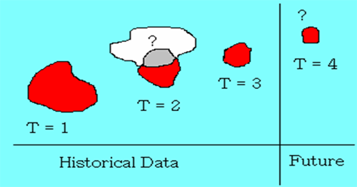
Tracking: Given an object in an image sequence (t=1,..,n), how to find the object at t = n+1 and beyond?
Prediction: Given databases of historical data and current physical and biochemical conditions, how to predict the occurrence of the interested object at a particular time and location?
Data Sources
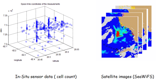
We use SeaWiFS satellite images (8 years) for the derived channels of chlorophyll and anomaly, and the in-situ cell count data from Golf of Mexico region (over 40 years). The satellite images are re-projected and cropped for the interested area.
Cross registration of both datasets is necessary because of the multiple spatio-temporal resolutions.
Missing Data Recovery and Spatial Filtering
Over 80% of satellite images contain clouds. As a result, the data below the clouds are missing. We use linear shape morphing to recover the missing frames. We then use Spatial Density Filter to remove the artifacts caused by sensory noises or image pre-processing. The algorithm is based on the distance between the points.
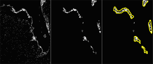
The left image above is the original binary image with sparse noises. The image in the middle is the result. The objects are grouped with yellow lines generated by Active Contour process.
HAB Object Tracking with Mutual Information
Mutual Information measures dependency between two objects in consecutive images. If objects X and Y are independent, then X contains no information about Y and vice versa, so their mutual information is zero.
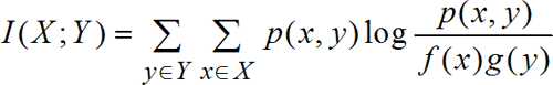
where p is the joint probability distribution function of X and Y, and f and g are the marginal probability distribution functions of X and Y respectively. The accuracy of 310 sample images is 98.73%
Trajectory of a HAB with Bézier Curve
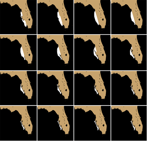
Bèzier Curve is a way that computer stores a curve in its memory. It consists of two end points and zero or more control points in between. Each point on the curve can be determined by B(t).
where the polynomials

Pi are control points which will be the centers of gravity in our case.
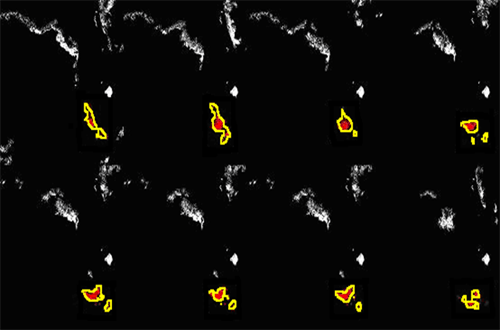
Marked Surface Object in a Grid
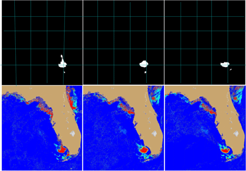
To merge the satellite images and the cell count data into one place, we use cellular automata grid to register the datasets. Each square in the grid contains both satellite data and cell count data. The images in black and white are the detected object. The images below are the satellite images, where the red color indicates the chlorophyll anomaly.
Spatio-Temporal Bayesian Model
SB(x0,y0,t0,I) = argmax P(c)P(x0|c)P(y0|c)P(t0|c)P(I(x,y)|c), for all c
where I represents the original or interpolated image, and I(x,y) is the 11 by 11 pixel patch of image centered at (x0,y0). P is the probability. P(c) = Nc / N, where Nc is the number of instances in the training set in which evidence c is true.
To handle the sparse dataset, we use m-estimation for the P(e|c) = (Nec + mp ) / (Nc +m ), p=1/r, where Nec is the total number of the instances in which both evidence e and class c is true. P is the prior of e0, and m is a constant which is the weight of the prior.
Results with 2,384 Test Samples (total 5,000 samples)
Table 1. Our prediction methods
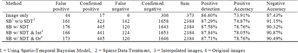
Table 2. The tabulated prediction reference results from reference [1]

Positive accuracy is the percent of the cases in which HAB is present and the model predicted correctly.
Positive accuracy = confirmed positive / (confirmed positive + false negative)
Positive detection is the percent of ALL predictions that are correct.
Positive detection = (confirmed positive + confirmed negative) / (sum)
References
[1] Tomlinson, M.C., R.P. Stumpf, V. Ransibrahmanakul, E.W. Truby, G.J. Kirkpatrick, B.A. Pederson, G.A. Vargo, C. A. Heil., 2004. Evaluation of the use of SeaWiFS imagery for detecting Karenia brevis harmful algal blooms in the eastern Gulf of Mexico. Remote Sensing of Environment, v. 91, pp. 293-303.
Conclusions
-
The tracking results show that the computer vision based object tracking algorithm can help to monitor the harmful algae across regions. It is able to automate the visual oceanography process. Adding human computer interaction may further increase the accuracy of the tracking at certain moments such as one object splits into several pieces, etc.
-
The prediction results show that the computer model can process more samples (over 2,384) than human manual process (188) with faster speed and better accuracy in positive detection and positive accuracy (see the definitions in section 8). However, it is 5% weaker in negative accuracy.
-
Our approach provides a repeatable computational process for Harmful Algae research.
-
The next step is to incorporate the models with operational monitoring and prediction systems in the field.
|